
Backing Foundational - Space Laser Ranging as infrastructure
Alexander Lange / Oct 1, 2026

TL;DR
Precise satellite positioning runs on a handful of ageing government observatories. Eighteen facilities produce 80% of the world's laser positioning data. The UN called the infrastructure "perilously close to collapse" in 2024.
Orbit is filling with working satellites, not junk. Catalogued payloads in low Earth orbit rose 5.1x since 2018; debris stayed flat.
Foundational owns the whole stack: retroreflectors, automated ground stations 10–30x cheaper than legacy, and the data platform. NASA values a tenfold cut in conjunction uncertainty at $1.5bn over 30 years and names satellite laser ranging as the way to get it.
We led Foundational's £8.2M pre-seed, the largest European space-tech pre-seed to date.
 Subscribe
At a time when the space economy is expanding drastically, its awareness layer depends on imprecise, outdated and decaying measurement technology. There are many methods, and laser ranging is the most precise. Current capability built on ~40 mostly government-funded laser ranging stations that are crucial to geodesy and reference frames. In 2024 the UN called that infrastructure "perilously close to collapse." Foundational is rebuilding it as a commercial network. With Inflection we led the company's £8.2M pre-seed financing round with participation from Backed, Adjacent, Final Frontier and Type One. You can find the press release here.
We met Hira Virdee and Dave Gooding in spring 2024 and closely followed their work at Lumi Space, a grant funded company doing laser ranging R&D with customers including ESA and the UK Space Agency. Over time our conviction in the market need for a commercial SLR (space laser ranging) network grew and led to us seeding the new born entity, Foundational.
value propositions
Space situational awareness (SSA) is the practice of tracking, characterizing, and predicting the positions and movements of natural and artificial objects in Earth's orbit. Space (or satellite) laser ranging is a highly precise technique used to measure the exact distance between Earth-based stations and orbiting satellites using short pulses of laser light.
How it works; A laser pulse is fired at a retroreflector on a satellite. The return is timed precisely, such that you get the range to millimetre precision, out to 2,000 kilometers, day and night. Today, operators work from radar and optical tracking, resolved to meters and kilometers, or onboard GNSS which can be unreliable and puts critical assets at risk. Spacecraft are maneuvering on vague probability cones and trust a public catalogue they cannot independently verify.
This status quo leads to several high stakes challenges downstream, such as:
(1) Acute collision risk and poor conjunction decisioning for satellite operators. Current orbital catalogs and ephemerides are meters-to-kilometers uncertain. Hence, false positive conjunction alerts stand at >99% and lead to unnecessary fuel burns, shortening a satellite's lifespan.Foundational provides cm-level, high-cadence ephemerides. A spacecraft's position and velocity are timestamped and packaged in a live stream of updates via their global SLR network. Using this stream, operators get far more accurate, timely collision probabilities.
(2) Unsafe, expensive Rendezvous + Proximity Operations (RPO) and In-Orbit Servicing (IOSM): RPOs require tight relative navigation at centimeter scale. Current SSA (= space situational awareness) and commercial data don’t support reliable autonomous docking manoeuvers. Foundational offers precise relative positioning allowing for faster and more secure maneuvers and ultimately extended satellite life. It holds the potential to make servicing commercially viable at scale. Operating from current SSA data at 10-100m accuracy means RPO relies heavily on onboard sensing only; accurate data means these sensors can be checked and validated through key mission stages.
(3) SSA (= space situational awareness) data fragmentation: SSA data is fragmented across classified government feeds, commercial optical and radar catalogues as well as proprietary APIs. Operators want a trusted, single source of high confidence truth for control and regulatory compliance, and as the standard to which other data is compared. Foundational is building a federated data hub that ingests external data and anchors it to laser-derived "ground truth".
As orbital positioning data is imprecise, the downstream effects on high stakes terrestrial services are devastating. This is where we see (by far) the largest commercial opportunity going forward:
(4) Crumbling infrastructure in geodesy: Geodetic data consists of precise measurements of the Earth's shape, gravity field, and spatial positions over time, gathered using satellite and stellar technologies. What happens if we can improve positioning data by 1000x? Atmospheric density forecasts would improve security and fuel efficiency in aviation and space missions. GPS precision could jump from 3-10m to centimeter scale, thereby improving navigation for drones, robots and autonomous vehicles. We could measure the levels of lakes, rivers, harbors and oceans at cm scale with improvement potential for shipping and insurance businesses. All of this requires modern, resilient infrastructure.
product
Foundational is building a vertically integrated stack for space situational awareness data (SSA) composed of three elements:
identify: the retro-reflectors that fly on the satellite
track: the autonomous ground stations that track them
analyse: the intelligence platform taking external and proprietary data in (distributed through SDKs and interfaces)
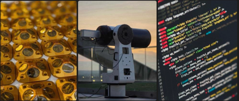
Compared to the existing stack of ~40 stations that have been built from 1960 to now, which are focused on science, the Foundational stack enables commercial services to make use of this well-proven technology.
market
The most immediate market for space laser technologies is the space industry. Today it underpins some of our most critical infrastructure when it comes to ground observation, tele-communications and defence. By gradually unblocking the launch bottleneck we expect orbit to fill up significantly over the decades ahead, driving up demand for high precision, real time object tracking.
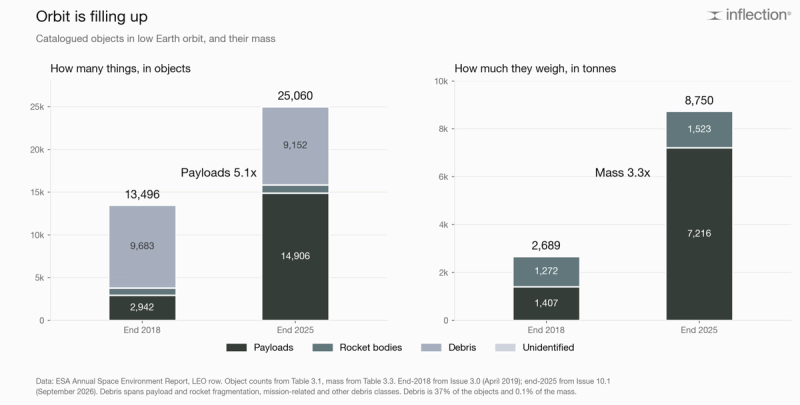
Catalogued objects in low Earth orbit went from 13,496 at the end of 2018 to 25,060 at the end of 2025. Mass went from 2,689 tonnes to 8,750 tonnes.
Payloads went 2,942 to 14,906, a 5.1x rise. Catalogued debris went 9,683 to 9,152, slightly down. Rocket bodies barely moved. Another angle is to look at mass because collision energy scales with it. Payload mass in low Earth orbit went from 1,407 tonnes to 7,216 tonnes in those seven years. Debris makes up 37% of the objects up there and 0.1% of the weight.
Looking forward, there are plenty of estimates one can use for some scenario planning; however the spread is rather large:
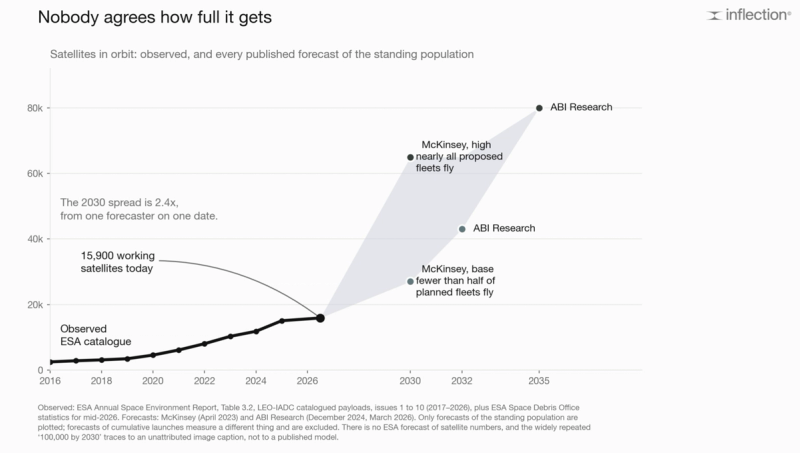
McKinsey's base case puts 27,000 satellites in orbit by 2030, on the assumption that fewer than half of all planned fleets ever fly. Its high case puts 65,000 there, assuming nearly all of them do. It's a 2.4x spread from one forecaster on a single date. For comparison, ABI Research reaches 80,000 by 2035.
The gap between what is filed and what actually flies is the reason for such large spreads. Thirty-six megaconstellations have filed for 2.3 million satellites with the ITU. Just over 13,000 have launched, which is 0.56%. The counter example is that Starlink's first generation launched 107% of what it filed for. A large part of this delta could be attributed to the launch bottleneck, which has received a lot of public and private governmental money in an attempt to solve it.
Besides the functional objects in space, debris started to become a real challenge that is expected to grow over time. The margin for error collapsed with rising satellite counts. A December 2025 paper introduced the CRASH Clock, which measures how long LEO would last before a likely catastrophic collision if satellites stopped manoeuvring. It came down from 164 days in 2018 to 5.5 days in 2025. I have been writing about this tail risk in When LEO fails: the case for stratospheric infrastructure.
The space market alone represents a multi billion dollar market opportunity for Foundational's data feed products.
Beyond that, we expect opportunities to rise in various industries around geodic data products, see under (4) above. As the technology landscape matures, new laser based applications might emerge, such as LMT (laser momentum transfer) - the physical process of using light to exert force on an object and alter its trajectory. It could be used for debris removal (moving debris out of the way), counter space operations (moving debris into the way) or as a propulsion system for example. Laser communications and power beaming are adjacent markets worth tracking.
our thesis
The same way fiber optics became the backbone of the internet, lasers are becoming the backbone of space operations for tracking, propulsion, navigation and communications through photons. Whoever builds the hardware backbone first will yield GPS-equivalent platform power.
For tracking and navigation services, ground based laser ranging is far superior to space based ranging systems because (1) they use massive, heavy telescopes (requiring stable, secure foundations) to capture weak photon returns whereas space based lasers are subject to payload limitations, costs and amplify uncertainty on their own location. (2) Maintenance, upgrades and component replacement are simple. (3) They can operate for decades vs. being limited to orbital decay, fuel limits and radiation damage to electronics.
Building out the ground station network requires access to exceptional talent in optics and laser systems which Foundational staff have built up over decades of R&D in the field. As there are enormous engineering challenges and complex permitting procedures, the hardware network creates high entry barriers that are very hard to replicate.
The development of a foundational data standard will yield network effects. The more objects are tracked and time stamped, the more precise triangulations and algorithms will become, again increasing data quality for new customers.
We are beyond excited to join Foundational's journey. If you're operating constellations or see other business synergies, don't hesitate to contact us.
#space#orbit#laser ranging#space tech#LEO#optical#laser momentum transfer#ground station#robotics
Related
Subscribe